JBA Consulting
We were tasked to develop a new flood forecasting model and warning thresholds for the River Ayr and Annick Water in
Ayrshire, Scotland on behalf of SEPA. As part of this project, we needed to recalibrate SEPA's existing forecast models for
the River Irvine and provide revised flood mapping for the Upper Ayr using 1D/2D modelling.
Challenge
Flood forecasting for the River Ayr and Annick Water
Location: Ayrshire, Scotland Client: Scottish Environment Protection Agency (SEPA)
Solution
The forecast system comprises:
- Five gauged lumped Probability Distributed Models (PDMs) for
rainfall runoff modelling
- Six ungauged lumped PDMs and five 1D Flood Modeller (FM) Pro
routing models
- Three hydraulic models and eighteen forecast locations
david.cameron@jbaconsulting.com | www.jbaconsulting.com
Benefit
The new flood forecasting and warning system is now operational, and improved flood mapping is available.
Flood warnings can be viewed on the SEPA website. To view the Ayr and Annick Water data expand the "Ayrshire and
Arran" section.
The forecast locations are at key warning areas and at gauging
stations, with error correction at the gauging stations.
We reviewed ratings and developed new ratings, including at the
key gauging stations Dreghorn, Mainholm and Shewalton. We
estimated flood warning thresholds, through the development of
eight new FM hydraulic models.
We carried out end to end testing to ensure consistency of results
between the models and the operational versions on SEPA's
national flood forecasting system FEWS. In addition, we
undertook flood mapping of the upper Ayr using a linked 1D/2D
Flood Modeller/TUFLOW model, to improve upon SEPA's
national flood risk map outputs.
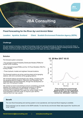
Flow routing from Limmerhaugh
gauging station to Catrine gauging
station on the upper Ayr. Observed =
dashed line. Simulated = solid line