JBA Consulting
The record-breaking rainfall associated with Storm Desmond caused severe disruption, flooding 5,200 homes across Lancashire and Cumbria (Met Office, 2016). Several major roads across
the north of England and Scotland were flooded. There was major disruption to rail services in the north of England and a landslide closed a section of the West Coast Mainline rail tracks
between Preston and Carlisle. 43,000 homes across north-east England were left without power and on 5 December 61,000 homes in Lancaster lost power when the electrical substation was
flooded (Met Office, 2016).
Challenge
Storm Desmond was a significant storm event that brought severe gales with gusts up to 81mph and record-breaking rainfall to southern Scotland, the north of England, Wales and Ireland from
Friday 4 - Sunday 6 December 2015. The worst impacts were felt in Cumbria, England, where the Honister Pass recorded 341.4mm of rainfall in the 24-hours up to 18:00hrs GMT on 5 December, a
record rainfall for the UK. The period between 09:00hrs on 4 December to 09:00hrs on 6 December also set a new 48-hour rainfall record with 405mm rainfall recorded at Thirlmere in Cumbria in
just 38 hours.
Storm Desmond using Flood Foresight
Location: Northern England, Southern Scotland, Wales and Northern Ireland
Solution
Date: 4 - 6 December 2015
To retrospectively apply Flood Foresight using Storm Desmond data to develop future response actions.
Real-time and forecast flood maps, before, during and after flood events.
There are three modules within Flood Foresight; Rainfall Screening, Flood Forecasting and Flood
Monitoring.
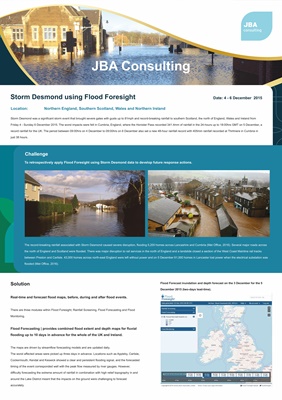
Flood Forecasting | provides combined flood extent and depth maps for fluvial
flooding up to 10 days in advance for the whole of the UK and Ireland.
The maps are driven by streamflow forecasting models and are updated daily.
The worst affected areas were picked up three days in advance. Locations such as Appleby, Carlisle,
Cockermouth, Kendal and Keswick showed a clear and persistent flooding signal, and the forecasted
timing of the event corresponded well with the peak flow measured by river gauges. However,
difficulty forecasting the extreme amount of rainfall in combination with high relief topography in and
around the Lake District meant that the impacts on the ground were challenging to forecast
accurately.
Flood Forecast inundation and depth forecast on the 3 December for the 5
December 2015 (two-days lead-time).