8.68 Chapter 8
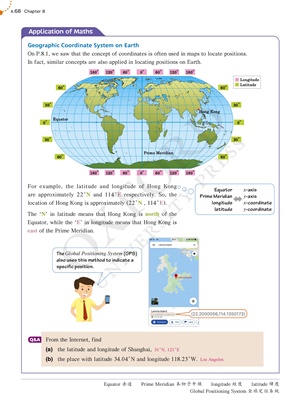
Geographic Coordinate System on Earth
On P.8.1, we saw that the concept of coordinates is often used in maps to locate positions.
In fact, similar concepts are also applied in locating positions on Earth.
180° 180°
0°
60° 60°
120° 120°
180° 180°
0°
60° 60°
120° 120°
60°
60°
60°
60°
30°
30°
30°
30°
0°
0°
Longitude
Latitude
Equator
Prime Meridian
Hong Kong
For example, the latitude and longitude of Hong Kong
are approximately 22cN and 114cE respectively. So, the
location of Hong Kong is approximately (22cN , 114cE).
The 'N' in latitude means that Hong Kong is north of the
Equator, while the 'E' in longitude means that Hong Kong is
east of the Prime Meridian.
From the Internet, find
(a) the latitude and longitude of Shanghai,
(b) the place with latitude 34.04cN and longitude 118.23cW.
Q&A
Application of Maths
Equator ԏ༸ Prime Meridian ͉ڋɿʹᇞ longitude ܓ latitude ᇗܓ
Global Positioning System Όଢ֛Зӻ୕
Equator
Prime Meridian
longitude
latitude
x-axis
y-axis
x-coordinate
y-coordinate
The Global Positioning System (GPS)
also uses this method to indicate a
specific position.
31cN, 121cE
Los Angeles